Sunday, October 22, 2023

Wherever you go, it's bound to rain.

Everyone knows that when you list skiing, Colorado is number 1.

Everyone knows that when you talk about the best skiing place you have to go to it's Alta.  No, it's Jackson.  No, it's Japow.  No, it's Stowe in a Nor'Easter.  No, it's Bridger when the Cloud wait that's Jay, wait, what if they's a hurricane and Sugar and Beech are open in October on like 36 new and, no, it's Mammoth in May, but, no, that's Alpental in May, and

A nice snowperson.  Silver Queen lot, Bogus Basin, Boise County, ID.


Sorry.  I'll start over.  Readers of this blog* will know that we do not choose bests without at least our tongues firmly planted in our respective cheeks, if not outright lies.  (Thanks, Richard Russo, I think.  Read his stuff, just the same.)  If I make a list, I leave spots open on purpose.  Or we make a top ten that's like 40 or 7.

There was one turn, though, one that cannot be beat.  It was somewhere near Flush Gap, whether above or below, I cannot remember.  It was a Thursday in February, the day my friends in a band I used to be in released an album, with a party in some joint in Tacoma I can see but whose name I've forgot.  This particular turn was a left, or a right, it doesn't matter particularly, but it was a turn.  I was on the ol' Jaks, that beautiful matte orange beast, maybe the last actual Karhu ski, maybe not, I can't recall when K2 knocked down their door and ruined everything.

Oh, dag, I loved this ski.  Maybe it was the time in life, like that second Death Cab record.  Who knows.  Still, armpit deep, man, it's a trip.

I can remember many ski days, from all the years.  I don't have perfect memory, like I don't have perfect pitch, but there are just some things that stand out.  The weather the only time I threw a no-hitter and the way Kellen Hall's Pa accused me of cheating.  The second and last homerun I hit, the one that Jewett Gibson argued and argued over until the ump called it a "ground rule triple". Which doesn't exist, but whatever.  Who's counting?  Who's holding a grudge? I'm not mad, yer mad.  I hit that homerun off his younger son, should that matter.

That one run in the Cache Run, February of '99, all alone and, not gonna lie, a little afraid of how things would turn out.  So clean, the first time I ever truly understood.  The Tatoosh, summer of '008, my knees bruised from wearing knee pads under my Carhartts cos I forgot my bibs, to the point where I had to tell Catherine to look the other way at the bottom and top of a couple laps so I could remove or install the pads on my knees with my pants down.  That last run in utterly beautiful summer corn, smooth, unending, ending too soon.  A warm and unforgettably satisfying Guinness at the trailhead with my hummus and Tillamook cheddar and grip of spinach pita pocket.  A long day with a good friend.  That whole pitch, several pitches really, hoping it would never end and I'd somehow simply ski off the edge and never be seen again, like Bo Jackson in '87 after that 91 yard TD and he kept running off the field and to me, six years old, he ran off the earth and to some finer plane, some elevated place where folks like him lived, Usain Bolt, Mikaela Shiffrin, Jimi, Beethoven, Florence Price, that sorta place.  I didn't, though, I just pulled up at the bottom, gave Catherine the low-pole, probly (maybe not, but it was My Thing) said "I like skiing," and kicked the skis off.

That one turn, though, near Flush Gap, February of '006, may it reign for eternity.  Hand forward, snow to my tricep.  Inimitable. Unforgettable.  Lee Cohen deep.  Like the shot that I could never shake, the one that precipitated our ill-fated move to Utah.

This one.  Shot by Lee Cohen, aka, well, The Best. Powder Magazine, way back when.  The Utah Issue, somewhere around the turn of the century. The cover, if I am not mistaken.  You will not be surprised that I still wear leather gloves because of this shot.  I still prefer race poles, too.  Just look at that shadow.

Chet said he was scared, at the bottom of Lower Northway.  He pulled the cord.  I can't remember the words, but I was as breathless as he.  Two straight runs, deeper than anything else I have ever skied.  Deeper than everything else.  Impossible, like the first time I heard Interstate Love Song, or Loowit from the top of 6 on a cold January Monday.  Chet was the Snow Safety guy at the time, number 3 on Patrol.  I bought my second car from him, a red, red GL.  That glorious little wagon and I grew up together.  Moved to Bellingham, failed at school, skied for two winters of ignorance, bliss, lust, who gives a shit cos the second winter, '002, right after we all lost our innocence, or at least us Gen Xers, was yuge, like an ego or a sophomore crush.  One stretch, I skied 20 straight until I couldn't even put the boots on.  That day I drove Twig to the doc after he thought he blew up his knee, where I almost hit Amy Howat in downtown Bellingham with 3 feet of rooftop snowpack when the ski rack finally released the last 3 weeks of puke, I mean, what are the chances of nearly hitting the owner's daughter with a pile of snow 60 miles from work?  That kinda winter.  And still, that day out North, through Flush Gap in armpit-deep, that stood above.  I don't remember the bus back to A Lot, but I remember the grader finishing the Northway Lot and the next run, you couldn't tell he'd been there. Eight inches in less than two hours.  That Cascade Spring speciality.  

I was probly buried like Snowy Owl the 8 foot rock.


I remember now; it was a left turn.  Right foot out front, left knee to the ski, that gorgeous Finnish plank.  Right hand ready to plant the pole, left foot flexed like a bow.  Right tip barely above the snow, left ski buried along with those Bumblebee T1s.  Perfection, if that were possible.  Appropriately, I'm still paying for that turn all this time later.  I can't tele right now, the tendons and ligaments and weak muscles all conspiring against any ambition I may have once held.  Anxiety like a block of lead in my chest.  It's a joke, really; all those years just ended, like any run does.  Reflection Lake and Catherine's green 5-Speed Outback after that long and immeasurable Tatoosh line; the Northway Lot and the bus, Chet frantic on the radio telling Mountaintop to close the gates; the bottom of Ariel on Closing Day of 2013; Sweetzer Summit in a snow flurry, Thanksgiving of 2016; Acme in October of 2000 in the red GL, Katie singing along with Adam Duritz, "gettin right to the heart of matters", knowing, without really knowing when, that something else was next, something different but similar.  More yearning, more longing, that very characteristic Gen X nostalgia for something still here and happening, or conversely, chasing after what is already gone; what was never really there in the first place.


Title is the second part of the line from Suzy Boguss' "Like the Weather". I don't know, I just really like that song right now. I even tole Amy last night it was my favourite country song of the moment. Still, Interstate Love Song.  There's a reason it's got something like 333 milliones of listeners on the Spotifier.

*Joke's on me.  There aren't "readers of this blog".

Thursday, October 12, 2023

If it's anywhere, you'll find it.

The stretch of US 40 from somewhere east of Duchesne through somewhere west of Vernal could be anywhere. It feels more like the Great Basin to me than anything, probably because I know how that feels more than I know the Rockies.  The highway curves around the north end of the Uinta Basin, empty when it's not strewn with those sorts of dreams and garbage that pile up in the unwanted places.  It's You-inna, bee tee dubs.  Utah.  Just nod.  This zone is best at speed, just an isolated, dirty section of highway otherwise surrounded by some pretty and interesting country.  It's completely unfair to judge Roosevelt for being hard-pressed.  Perspective, I guess.  Folks live here, have for millennia.

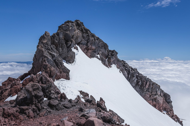
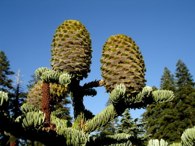
Layers and rocks and hoodoo and stuff.  Dinosaur, UT/CO


To the east is Dinosaur, historically among the lands of the Fremont people.  They predated the Ute and Paiute and Navajo.  Dinosaur is known for its namesake, but it's a stark, beautiful landscape. Pink rock and meanders in the Green.  The Uintas curve around the north side of the basin, protective or ominous, should you be inclined to any specific temperament. There's dinosaurs in them hills, of course.  Turned to stone by the epochs.  It's the rock that you see, though.  From a distance, up close, from the grocery store in Vernal and the Church south of Naples.  Ever present.

It's an empty country, this.  Counting the miles, delineators whipping by the passenger window in the dark, pronghorn dancing off in the distance as though they aren't faster than just about any damn thing that isn't made of metal and physics and dreams.  Silhouetted against the faded blue of that huge sky stretching from SLC to Denver.  As you head east into Colorado at the town of Dinosaur, there's a conspicuous and somewhat mysterious ridgeline curving around you.  Snake John Reef.  It's a sharp little seam in the valley floor, about 6 miles long.  Artemisia and Juniperus and sunbaked earth.  The entire region is mostly sedimentary rock, layer upon layer upon layer.  Streaks of colour.

You can tell those are aspen because of the way that they are.


Eventually, US 40 will drop you off in Steamboat Springs.  I'm certain there's skiing there, but I've never stopped for longer than it takes to grab an iced tea and some petrol.  You can head south to Wolcott and the Eagle River Valley, or southeast through Kremmling and up the Blue River drainage into that most storied of counties, Lake.  You thought I'd say Summit, but if you're headed there, I bet you flew to Denver and hopped in a limo.  Or teleported in on the third rail of some business jet.

Out in the open, the fields roll unevenly to the horizon, sheep and coyote and pronghorn and mule deer.  Artemesia and emptiness and every so often, virga from a passing storm.  The Yampa off to the south.  A story in itself.  Empty meanders through a quiet valley, skirting to the south of the archetypal cowtown of Craig.  To the west of Maybell, it dives into an incredible canyon, walls a few hundred feet high or more.  The canyon walls, the layers of sediment, and the millennia of erosion are reminiscent of the desert Southwest.  Surprising clefts; a deep, cool river bottom.  Friendly shadows.  To the south, it's hill country until the Eagle River, where the Sawatch begin.

Somewhere after the Sawatch began.


I  grew up on the Wet Side, on a lahar plain.  The trees come in close, dark and broody and wet.  Fires don't happen too often, with the sort of consistently high hot-dry-windy index that plagues the Dry Side being impossible most of the year due to the ocean that's always just out of sight, over your shoulder.  The peaks aren't visible from all viewpoints in and around my hometown, a sort of mountains-for-the-hills contradiction made yet more immediate by the forest you can't see through all the conifers.

The Bogus Basin Road is none of this.  It starts out in town, just another city street.  Harrison, a historic, boulevarded lane of sixteen blocks.  You slide through the stop sign at the Elementary School by the old church, now being drawn and quartered like so much of the Treasure Valley, into expensive domiciles too fancy to be called houses, with tiny lots not much bigger than the building's footprint, and then the road just pitches up.  Sixteen miles, with little relent save the half mile or less down into Miller Gulch.  Twisting and turning, made more impressive by the consideration of this highway's history.

Okay, sue me. Sometimes the trees come in close.

Time was, it was dirt, naturally.  One lane, up in the morning and down in the evening.  Before the houses, before the pavement, it was a muddy slugfest just trying to get up to the hill to ski.  It's been paved since '62, after about 25 years of hoping it'd be too cold for mud and that the snow would be crunchy enough for good traction.  It still gets a little squirrelly sometimes, especially in the band between five and six grand.  I've never truly lost control on the road, and only once of any consequence in almost 30 years of driving.  There are some corners, though, to which I give more deference than others.

Most of the new housing at the bottom of the road has come in the last fifteen years.  This is editorialising, I admit, but it is out-of-place, at best, and at worst, a bad idea that should never have been permitted.  There are more rooflines in this small little swatch of grasping nouveau wealth than in some entire boroughs in more tasteful locales.  At the moment, it thins at the first right hander and ends at the second left hander.  There are homes above, and some even ostentatious, but the worst of the ugliness is over, and one can see the foothills and Boise Ridge above it all.  There's room for a hawk and a harrier, for a handful of deer and the seasonal sheep drive.  Cattle in the spring in the draws, and the flies they bring looking to break the splatter of new-grass manure down before it dries and hardens and desiccates, unavailable until the Monsoon finally makes it this far north in late summer.  It's just grass and water, folks, no need to be afraid.  These are rangeland cattle, that hippest of beef, the mythical grass-fed flatiron.

The Bogus Basin Road just goes on, and on, and even if it takes a hundred shifts, it's still better in a manual than any automatic.  Better still if you have the fitness to climb it on your road bike.  The descent is fast, interesting, challenging, and scenic.

Up above the Zombie Apocalypse house, there are tandem rock piles that from below look like a big bison and a little bison.  Little Bison from above is Face Rock.  Past the county line, there's a hard left hander that'll sneak up on a fool if he or she isn't ready, and in midwinter it dives into the shadows.  Some weeks it doesn't melt out like the more exposed pavement just above and below.  Past the big turnout that overlooks Daniels Creek, the road dives into shadows again, starting the really greazy part of the drive.  It stays chilly, the northwesterly aspect not receiving any meaningful sun until March.  Not coincidentally, it's here at the Ten Mile that you'll likely catch the slow driver who will not pull over for anyone.  In our 100% completely totally scientific polling of a very representative swath of Treasure Valley residents, the driver will likely be in a large-to-huge truck or a very capable Subaru. (Okay, it's me, Amy, some BBSEF coaches she worked with years ago, our paid High School intern at the shop, Parker, Legendary Bear National Team Member CarHams, and Ryan (The Owner).)

Little Bison from above.  I swear it's a face.  You believe me, right?


Some days the snake is ten cars, sometimes thirty.  One Sunday last year, it was vintage Puget Sound stop-and-go all the way to the upper lodge, almost two hours.  And I still found good snow because heads is trippin and they ain't got that shit on lock.  (Sorry, the memory of that drive glitched my software.)  I mean to say I skied Chair 5, where most folks never venture, even when that's the exact ticket for which they drove this twisty dervish of a glorious mountain road in the first place.

The last four miles are in the trees, still turning this way and that, dodging shadows and periodically giving a little view of the Sinker Creek drainage to the left and the upper reaches of Boise Ridge, and the ski area itself.

Heading down, it's always a bit bittersweet.  I've never grown out of the desire to just live in the hills.  The view is expansive, the drive easy if you take it like a sane person, exciting in the best of ways if you push it and there's a clear view.  Sometimes it's second gear, sliding corners every so often, hoping it stayed cold behind you but knowing that somewhere along the line it'll get greazy again, that you'll drop out below the stratus deck, town glowing below in the early night, mist on the windshield, night skiers' headlights moving slowly up toward you, who knows what spirits looking on from the Purshia and hackberry.  Just don't forget to let the trolls out at the Troll Gate.  Brian Galbreaith tells us that they don't want to go home with you.

Orcinus orca, Salish Sea local, just downstream from the Nooksack.


The light isn't cold, not this deep in the North Fork.  Doesn't matter if it's snowing, or even if there's snow on the ground.  It's Western Washington, and it really doesn't get cold.  Nor is it threatening, mysterious, or any other damn thing, except dark.  The rain is dark.  The trees are dark.  The light is dark.  The Killing Woods that my buddy Todd talks about are here, of course.  Grand fir, red cedar, Devil's club, salal, hemlock, rotting tree trunks and maybe an owl or two, Strix occidentalis and whatnot.  There's a moment, every few weeks, where it's been puking and stayed cold behind the front, and the light just jumps.  A painting.

The game was reciting what was ten miles ahead.  It kept me awake.  Ten miles above the DOT at the North Fork is Artist Point, buried a few months ago under the lower 48's snowfall outlier, that tiny convergence zone that centres on this huge amphitheatre, the Headwaters of the North Fork.  The Nooksack doesn't drain massive square footage, but it is wet, all the time.  Feet upon feet in a normal winter.  Many species of ferns drip into the organic duff that clutters the forest floor.  Slugs and centipedes and beetles and passerines.

The first ten mile was somewhere near Nugent's Corner.  Highway 9 heads north to Canada.  There's a market, and today a roundabout that wasn't there 22 years ago.  The second, I don't know, somewhere south of the North Fork Beer Shrine.  A random bend in a highway made of bends, in some trees along a highway buried by trees.  I didn't really get interested until Kendall.  Or should I say, I stayed awake most times until Kendall, when the dark got darker and the trees closer.  Kendall's just about the 23 mile, and Maple Falls, home of Maple Fuels Wash-a-ton, just past the 25 mile.  35 is just past the Snowline, which is just upstream from Glacier, which is the last actual town on 542.  Then comes 36, and I could start relaxing.  The DOT is at 46, and then it's twisty, windy, steep, and sometimes gripping until the E Lodge just across the lake from Chair 1.

Just past the DOT, as soon as you cross the North Fork for the last time, there's a 90 degree left.  It never gets any sun.  My brother John talks about spinning a 360 there with Kelly Jo, who incidentally is both Craig Kelly's ex and one of the better cooks whose food I've had the pleasure of eating.  He says she told him to do it again, meanwhile he's tryna get his BP down below 200/150.  Another evening, heading up this time, Eli spins out in his old Metro, that green three-cylindered beast.  I might be misremembering, but I'd just finished my EMT and I'd swear his heart rate was like 199.  I checked.

Shuksan, Upper North Fork of the Nooksack, basically Canada.  Just ask the locals. USGS photo.

Two mornings, same corner.  John forgot his license--and I assume wallet, or he just had one of those moments--so he had me drive the Blazer.  I didn't know the corner, just a couple weeks into my first winter at Baker.  The sleet was tapping on my window on Garden, the streetlights a streaky orange.  It was good going until the corner, having dried up out by Barclay, maybe the Haggen.  That corner, though, just below the 47 mile, it doesn't melt.  Or if it does, it's only so that it may refreeze again, and it was definitely refrozen.  It was also snowing again, as evidenced by the DOT plow driver who pulled us out.  John said he saw his life in a flash, like in the movies.  Fortunately, the snow in the ditch by that massive Doug fir rootwad was rotten, crunchy, non-supportive.  We stopped less than a foot from major problems.

Second morning, late that winter.  I hitched up from Bellingham with my roommate and his buddy.  They were seniors at one of the high schools down there, not sure which.  Roommate's buddy, we'll call him Buddy, had an early-model Tacoma, long before they cost twenty fifty grand for a twenty-two-year-old model with 257 thirty billion million on the spinny thingy.  Two doors and a canopy.  I'll give him this, he had sand bags against the head of the bed.  And a camp chair, which was surprisingly comfortable.  The dark rolled past, snow from town, continuously whipping by at 60 or so, his confidence far outreaching his experience or skill, as evidenced by the ridiculously quick 360 he did not mean to turn at the left hander just past the North Fork bridge.  The snow was going in the correct direction, toward the back of the canopy, then it slowed up until it was headed the other direction entirely.  Without a beat, it stopped and then headed toward the back again, although at a much steeper angle now that he'd slowed down below 35.  Buddy trundled the rest of the way to the E Lodge at codger speed, but we made it.  Six miles he had to calm down, and he was still white as a Peanuts bedsheet ghost.

Somewhere on the first mile or two or three of the climb above the DOT, Shuksan appears through the canopy, that matriarchal Orca.  The Price, the Hanging, and the White Salmon Glaciers white above the deepest green.  October wet, August dry, March sunny break, she's there above the rest.  The remainder of the drive is what you'd expect.  Breathless anticipation, abject fear at 2 a.m. o'clock in the morning when there's a foot of variable on the highway and all you can do is hope the cat in front of your '87 GL didn't drive over the edge first, ghosts and those cold-day sprites, floating ice crystals no bigger than a flake of black pepper.  A scree field that'll swallow a liftie's Jetta like a batter swallowing his chaw after a particularly high insider.  It's sub-alpine, already, not even to four grand.  Then, depending on the day, it's time to boot up, time to go to sleep, time to walk along the Chain Lakes, eat breakfast after Buddy calms down, or just sit in the September sun and watch the pika make hay, the sky eerily empty on the 12th of September.

I didn't believe Pa when he tole me, but then I seent it up on ol' Table Mountain.  NPS photo.

Title from Lee Roy Parnell's epic road poem, On the Road.  Better than the book, I think.  Kerouac was, um, overrated.  Fight me. Besides, Kerouac could kinda write, Lee Roy can shred the slide guitar.

Saturday, October 7, 2023

I love the bass when it's low and mean

I wish I had a picture of the sunburn my calves got the first time I hiked up to Camp Muir.  I'd kinda just slurred the sunscreen on quickly, and missed what ended up looking like flames coming out of my socks. Muir isn't a difficult hike, technically, just long. You leave Paradise at around the Or Fight* line and just keep goin until you need real alpinist gear and you're wondering who all these people are, sleeping at six in the evening.  The Muir Snowfield tops out a little over ten grand, at the divide between the part of Tahoma where you only worry about getting lost in the fog and the part where she's actively tryna off ya at every turn.  Being a snowfield and not a glacier, the Muir is skiable year round, easy in pitch if not in sightline. If you hike without skis, it's a long way down.

That first hike was with a kid who, to be blunt, was one of those friends you're friends with cos you think your friends are friends with him, only to find out when he's not around that nobody likes him and everyone is friends with him cos they think somebody else is friends with him, but in reality, you're all just kids in your early twenties, unforgiving, and now, looking back, maybe dude wasn't that bad. Kinda annoying in that socially awkward way that a lot of us were in our early twenties, and we just judged him cos we wanted to think we were better. Obviously, if he pulled some Me Too shit or like killed somebody and joined the Proud Boys, then maybe we were right.  Who knows where he's at, but we did some good hikes to some cool spots. Can't complain about that.

Strangely enough, it's Brett (I'm like 75% sure that's his name) who got me my first bike job, and damn near twenty years later, I'm still pretending to be a mechanic, building wheels in between those reveries of afternoon coffee, some sort of Scandihoovian almond pastry, looking out on a montane prairie, covered in snow.

Some boring volcanism at Camp Muir.

The first time I actually skied in October was around Halloween, or a little before.  One of those heartbreaking fall days you wish would never end.  It had snowed a little up at Paradise, not much, but enough to scratch a few turns into some frozen melt-freeze in the blazing but radiationally ineffective sun. Patches of grass.

It's hard to say the turns were worth the hike, let alone the drive up from Puyallup.  But then, if that's the math you're using, nothing is ever worth doing.  I try to ignore that sorta logic.  That day, let's say it was the 28th, probly '07, I just hiked until I found enough snow on a steep enough pitch, probly up around Pan Point or so. Seven grand, somewhere thereabouts.  I say snow, but it wasn't really.  I think I didn't even bother dropping the knee for fear I'd make too long a turn radius and be back at the car before I'd had my fill.  Joke's on me, though, cos sixteen years later I still ain't found "enough". I get by, yes, but at this point my desire outlasts my ambition. There's always a wisp of yearning hanging in the air like some deep subalpine valley in January where one house has a fire and the capping inversion is visible, just a lazy line of smoke about three hundred feet above the chimney.

I won't lie and say those turns were good, but they were memorable. Scratchy, challenging, even a little painful on my unprepared feet. When I got back to the old Legacy, I probly shrugged, looked up one last time at Tahoma in the late afternoon sun, and headed back to town. If I'm reading the calendar right, it was the 30th, right after Junior fired me from Bonney Lake Bicycles of Sumner, Washington. The start of the only good month of unemployment I've ever had.  The November turns that year outshone the October turns, but it doesn't matter.

The view from Camp Muir could be better.

October of '08, after getting skunked in the summer tryna ski Muir, Catherine was pretty gung ho about getting up there. It snowed early, and quite a bit. We were a day late, or maybe two, somewhere around the 12th.  She met me in Puyallup and we headed up in my Legacy. Another one of those days, clear, cool, visibility unlimited.  We didn't hit snow until above seven grand, what would be the toe of the Muir if it were a glacier. While swapping to skis and skins, we ran into a pro skier whose name isn't that important here. He was a full bedutchka to us, grunting and acting like we were in his way.  No answers to our questions, just an impatient gesture and he was off down to Paradise.  Any time I see his name today, I, too, grunt a little and act like he's still in my way.

The skin up from 7200' or so is long, long, long. Flat, in comparison to the sort of alpine lines most skiers dream about. I joke that the descent was the most exciting beginner run I've ever skied. You don't switch back much, just slorp and glorp your way along until the last few hundred vertical, where consensus holds that it's "steeper". The consensus holds, too, that the Muir Snowfield is only worthwhile for these early fall desperation quests.

Alas, the cognoscenti are correct.  The view from Muir is terrible. You only see a handful of volcanoes, there are cracks in the glaciers above, the rock is interesting only if you like rocks and volcanism. The valleys stretch below you lazily, and the Tatoosh look small at this distance.  The sun is benevolent instead of harsh, I mean, who wants that? The snowfield is long, and you'll probly just wanna get it over with cos skiing on a volcano isn't that special, is it?

You know what? Joke's on them.  Camp Muir is incomparable.  Millennia of volcanism tower over you, and this early in the water year, the underlying blue of the Cowlitz Glacier just over the divide peeks out from the crevasses, beautiful and ominous.  I know what they can do, and yet I can't look away.

The turns, ah, the turns, you ask. They were, well, challenging.  I'd built up excitement for the flat pitch, the long beginner run it would be, and then it was so sticky I had to hold each turn with all the leg muscles I could find. Tibialis posterior? Check. Soleus? Check. Adductor brevis? Check.  I don't even know what those are. Tele's hard enough when conditions are ripe, even more so when they are long past.  I didn't want it to end, but my legs did.  The two-day-old hot pow skied like you'd expect in the direct sun, that exposed southerly aspect.  The Muir fades skiers' left away from the Nisqually Glacier. It's so tempting to drift right and find the steeps of the Headwall, but there's no snow there off the glacier until the wet season systems build their snowpack, and it's not 1930 anymore.  The glacier no longer runs to the bridge.

The snow was so sticky, in point of fact, all I could do was a 30 metre turn and catch my breath on the transition, and repeat.  Eventually, the turns ended, the muscles could relax a bit.  It's still a few miles of dirt to the car from Pan Point, but the hiking shoes felt like slippers and it was mid October and I was twenty seven, in the golden years where you still know everything and your body doesn't yet hate you for seeking it all out. Eyes up, the Tatoosh growing with every step, and then the flat of the paved lot and the bemusement of the late-season tourists.  Low sun.

I guess this is cool if you're into that sort of thing. Nisqually Headwall, skiers' right of the Muir Snowfield.

The third October day was a full moon, '013.  It had puked at the hill, surprising for mid October in Jackson County.  Mt Ashland is the tallest point, and by most standards it isn't that tall. Seven and a half grand, give or take. The highest point on the Siskiyou Crest, recognisable from a long ways away.  The moon was low when I drove home from work in Medford, maybe a day or two before being truly full.

Amy was surprised at how ambitious I was when I got home.  Usually we'd make dinner and mellow out on the porch, a quiet evening above the bike shop, the heat of summer long past and the hippies long gone to warmer climes. Instead, we threw everything in one of the Subies and booted for the hill.

The lot was empty.  The snow was thick, and a bit orange from the town light reflecting off the thickening clouds.  A weak warm front passed through while we were there, changing the snow between runs from the first run in high quality settled-but-fluffy to a challenging crispiness. McLaughlin off in the distance to the northeast, Shasta just east of due south. The first run was delicious, the second a passing grade, but barely.  The warm air off the ocean was too much for the day old snow, and we called it a night.  Halo around the otherwise bright moon, a strange glow emitting from the Cascades to the east and the Bear Creek Valley below.

That winter never happened.  An early December storm dropped a foot in town on a whim. In the following days a burly Rogue Valley inversion set in and the snow just sublimated and the storm track never really returned.  The Weather Service called it the Ridiculously Resilient Ridge, to which the late Kim Clark added "Great" so he could just say GRRR.  My last turns at Mt A were in March that winter, dodging potholes in what rotten snowpack was around, never once dropping the knee.  I could never get a rhythm in anything that winter, and in truth, I haven't really found a good one since.

My last memory from that night was the ghosts of the Shasta Valley, Black Butte and Cottonwood and Anderson Grade and Black Mountain.  Basalt. Dark shapes, distinguishable more through memorisation of place than recognition of shape.  Old volcanism, uplift, and desert. Quiet, distant and immediate all at once.  Impossible to repeat.

From Eagle Point in the daylight rather than Mt A in the full moon, and frankly, just another volcano. See one, you seen em all.

--

I could have named this after the John Denver classic Some Days are Diamonds, but that would be too easy, no?

Title from The Judds' Turn it Loose, which is kind of a nice easygoing country song for folks who don't wanna try all that hard.  I mean, yes, I like the song.

Eagle Point gets its name from the eagle on McLaughlin that is visible in the shot above. I wish somewhere around the Sound with a boring name--like Burien or Buckley or Renton or Kent--was instead called Elk Head.  That'd be fun.

*54-40 or Fight, but you know that.

You can't even see the Eagle from up here.


Wednesday, October 4, 2023

If you stay, it'll get better.

 The last turn I made at Mt Ashland was the most painful single second I have ever experienced.  Broken arm, blowed out knee, wisdom teeth, lifelong back trouble, migraines, none of that hit like that moment by the rental shop, the only tele turn I attempted in all of the nearly snowless winter of 2014. 

Mt Ashland, Siskiyous, State of Jefferson.  Not exactly Mecca, but you'd be wrong to omit it from your dossier.  Just look at that gorgeous Riblet fan up there!  Seriously, get after it.  Photo via mtashland.com

The hills above Ashland, Oregon have a pretty diverse plant community.  To the northeast of town is oak savannah, right up into a high treeline made by Doug fir and ponderosa.  Down low, it's almost barren, reminiscent of the Great Basin.  Rangeland, sparse white oak that may have been more prevalent long ago.  It's hot, the afternoon sun hitting at right angles in three dimensions on the steep hillside.

To the south, it's cooler, calmer.  Where the heat on the southerly aspects northeast of town make the air feel hectic and the bugs aggressive, the steep, damp, dark mountains south and west of town are quieter, full of shadows.  The streams that drain the watershed are small, collecting together as they tumble.  The hillsides are heavy with the trees of many species, and the landscape changes with aspect and elevation.  The lowest forest is ponderosa and madrone, the soil a combination of slowly decomposing pine duff and even more slowly decomposing granite.  Late in the summer, it resembles moon dust on the trails.  As you climb the drainage, the ponderosa gives way to Doug fir, and eventually to mountain hemlock and Shasta fir.  I love conifers, and I'd be lying if I said I didn't feel there's a hierarchy among them.  Ponderosa is a widespread species, with many subspecies, and the Klamath-Siskiyou variety (ssp benthamiana) is gorgeous.  Red, red bark.  Tall, imposing, healthy.  Cones that won't kill you, not like a sugar pine will. Wet-side Doug fir, too, feels bigger and more, I don't know, anthemic than its Rocky Mountain counterpart.  It's the higher-elevation trees toward the Siskiyou Crest, though, that stand tall for me.  Mountain hemlock, reminiscent of but stouter than its wetland cousin the Western.  The droopy tops more upright, and the profile more suited to shedding snow.  Above them all, the Shasta fir.  It's a hybrid of some sort or other, depending on your perspective as a lumper or a splitter, of two majestic true firs representing two very different floristic provinces.  From the north, the noble fir, and from the south, the red fir.

Them's some cones, brati.  Abies x shastensis.  Pic from the American Conifer Society.

The crest above town is part of a bridge between the Cascades and the Klamath Range. Mt Ashland itself is the tallest peak on the crest, the tallest in the Siskiyou subrange.  Before we moved there for Amy's Masters program at Southern Oregon, the Siskiyous for me represented only the Summit on I-5, which frequently closes for weather due to its just-high-enough elevation and the sheer volume of trucks and other travelers who use it, and the Shakespeare Festival.  The three years we spent in Ashland showed otherwise, that the land surrounding it is a jumble and a crossroads, old and new piled up and twisted, with deep canyons and ancient species minding their own business.  Where here in the desert of southern Idaho I can count on one of Yoda's hands the conifer species, there are places near Ashland with ten or more in a small space.  The Miracle Mile due south in the Russian Wilderness has at least 17 different conifers, possibly 18, all within a square mile.

On a winter day with just the right flow, one can experience a twenty degree drop in temperature from Exit 14 to downtown, around two and a half miles.  My friend Rob used to live out by the golf course there, and one day when I woke up above the bike shop we both worked at to fog and freezing temps, he thought he'd ride in to work without a jacket because it was darn near sixty degrees at his house.  He walked through the door a little disoriented by the change.  This sorta deal isn't unusual under an inversion regimen, but that change is always with elevation, not just heading two and a half miles west.  It's that same Summit, the one that bedevils so many OTR truckers each winter, that allows strong southerly downsloping.  The warm Central Valley far to the south will be under high pressure, with the Cascades to the north being pummeled by yet another east Pacific low.  Wind will shoot the gap between Pilot Rock and Mt A, and drop down to the valley, heating as it compresses.  The flow usually isn't strong enough to scour the cold air much north of the bottom of the hill, so just that little Mediterranean pocket lives in blissful ignorance of the damp cold a few feet away.

The Bowl, Mt Ashland.  Them shits is right.

We moved to Ashland at the end of April in 2011, a couple days after our only nephew was born.  It was a long day, leaving Greenwater early and driving mostly straight to Ashland.  We got in late in the evening, and my parents helped us carry our lives up the twenty-two stairs to the surprisingly large apartement above the bike shop.  When Merrill and Ron tacked the apartment onto the building in order to fill the "owner-occupied" requirement that came along with being a retail spot in the Hysterical District, they were quite ingenious.  A spacious kitchen, stairs with storage leading up to a raised living room and one of the bedrooms, a ladder up to two rooms that could be offices, storage, bedrooms, a ganj-grow, whatever the Ashland hippie of the early 80s could desire.  It wasn't perfect.  The baseboard heating was inadequate to those damp inversion mornings, and the third-floor elevation without a/c or strong circulation meant we spent a goodly sum on fans and the loud window unit that did its best to keep us only somewhat too hot rather than way too hot.  The Armory (an historic building, to fit its surroundings) hosted shows sometimes that would keep us up late at night and into the early mornings.  We had a spacious attic that was technically shared with the shop, but Merrill hadn't really used it in some time.  The location downtown was ideal, walking distance to most things and riding distance to everything else.  We drove across town to the Shop'N'Kart by choice, because it had both the best prices and the best selection of any store in the valley, otherwise the cars didn't rack up many miles.

We left Crystal that year at the waning end of one of the biggest winters I have been a part of.  A particularly potent spring pattern coated the entire Cascades in a volatile snowpack.  Baker, for instance, got 227" in March. More than an average wet season, for instance, at Bogus, and a number that until this past winter ('023), I thought I wouldn't have the pleasure of skiing again.  At Crystal, it started snowing around the 15th of February, and for at least 8 weeks, there was measurable snow each day.  Not most days, each day. That could obviously be an inch a day for a week, but many times it was eight or ten or fifteen.  Colin Meagher had an ad in one of the bike mags that summer, a photo at Chinook Pass with Keith Rollins standing tall on his road bike, dwarfed by the fifteen-foot snowbanks.  Fifteen feet of snow in June, below 5500 feet.  It was a hard choice to make, leaving home, leaving that much snow behind.  It was at the end of a long run, frustrated, feeling trapped, maybe made a little in haste, but not one I would actually change if I had the choice.  We could have simply held on like the old barnacles so many ski area lifers become; crusty, angry, combative, entrenched.  Mossbacks.  It's easy to romanticise what might have been, but one doesn't really know, now.

THE Mossback.

We missed Closing Day.  Crystal moved on without us, got busier, more anonymous, hipper, more 'grammable.  I mean, the Silver Creek drainage has the same physiography, but don't tell all the new folks that. They DISCOVERED the place.  Mostly gone are our ilk, the Carhartt crowd.  LB is flying bush planes in Alaska, and last I heard, pounding nails when he needs to in Greenwater.  Abby's raising a family and fighting wildland fire.  Lizzie just got her Doctorate at the U in SLC.  Liza is in SLC, too, coincidentally, out of contact even though she is likely the fulcrum for Amy and me getting together and staying.  I lost patience and said some stuff and now there's just some good memories and a hope that she's doing fine.  Curtis and Dawn are long since broken up, Laura off doing stuff and I think she's also got a family, Brad has a Sugar Mama, his words, and a daughter.  The base area is a mess, and the community downstream is no longer a part of the day-to-day.  The entire goal of the new owners seems to be selling beer to bored tech workers and soliciting proposals from various middle-management.  (We watched one of these interactions this past February.  It was a scene from Office Space, to be sure.)

The night before we left, we shared some nachos with Sean Bold in Rafters The Bullwheel Rafters, hung out in B Lot with the few folks who were left, and then disappeared ourselves.  No closure.  We woke up, gassed up in Enumclaw, put our respective right feet down, and went to sleep in an entirely different place than either of us really knew.

Hurts to leave home when this is home. The King, CM Southback, on Pa's 75th. Shank Chute, Pinball, Pinball Face, the Toaster, Toaster Face, some rocks that probly have nice lichen communities, Samsquanch, A Basin Saddle where Eli lost his ski and made us lose valuable ski time all those years ago sorry Ma said it's best to forgive but Pa said it's more fun to hold a grudge or at least that's what I tell people cos it's funny I mean at least Brad laughed and Patrick guffawed.

Some years, Closing Day is timely, the second or third Sunday in April, with dirt showing through, sun, slush, and a kind of frantic last hour where you realise you are counting down the runs regardless of most skiers' superstitious fear of actually calling "last run".  Near panic.  Some years, the better and best years, there are a string of closings that last a few weeks, where if you have a thick enough wallet you can ski a handful of Closing Days without ownership, without the bittersweet drive downstream or the sad stumble into the E Lodge for one last night in the hills.

This year, ours was among the latest of any who don't normally do this sort of thing.  We expect that Mammoth will push into the summer each season--they made they 6th of August this year--as will A Basin.  Snowbird and Bachelor always aim for Memorial Day Weekend.  Timberline usually gets a Sunday or three in August.  Bogus, though, is among the crowd of areas closing regardless of snowpack, scheduled in advance, hoping just to make the projected last day.  Last year, we melted out in March and April turns were just hopping over dirt on the first Sunday cos, well, we can't close in March, now, can we?  Closing '019 was a deep day, 14 April, a bit of a surprise.  It'd been warm and dry on Saturday, and even though the forecast was for tenish inches, nobody thought it'd happen, but it was among my deepest days in an already really good year.

This year, though, was different.  Everywhere in the West had a good year, especially south of the 45th.  Everyone knows how big the Sierra went, but the Wasatch was at least one pay grade above.  Alta hit 900 for the first time on record, a mere 625" above the low set back when we were in Ogden.  Bogus--lowly, forgotten by the industry even though they started the affordable pass trend back in the 90s Bogus--hit 360" in mid May, 80% above average. Seven inches shy of Crystal, when in most winters the difference is Crystal 2, Bogus 1.  Or more.  We stayed open fully until the 16th of April, a respectable closing, then enjoyed three bonus weekends until a slushy, appropriately uncertain finale, the 6th of May.  It's the latest I have skied lifts at my home hill since 2002, and even that would require the asterisk of having moved back home after Baker closed.  It was bittersweet, of course, and I missed a good few runs waiting out a persnickety morning gut, and I left as unsatisfied as I always do.  Not because the turns were anything other than great.  They were memorable, and quiet, and mostly in the sun.  The corn snow piled up in places, ran smooth in others, rarely sticky, and, well, very much like I want from my May turns.  Sloppy, challenging, unappealing to most of the boozehounds who headed up only to find they didn't care enough to really do much.  A modest group of us hung out at the top of Chair 1 throwing snowballs until Patrol got impatient and quoted Semisonic quoting the apocryphal "you don't have to go home. . ."  I skied the Other Ridge to the Other Bowl at short-swing pace.  As many turns as possible, stopping long enough for Patrol to almost catch me before moving on.  Then, just like '011, I left unceremoniously.  Other folks were boozing in the lot, natch.  Honking their horns on the way out, yelling, whooping, doing what privileged white people seem to do in these situations. 

6 May 23.  Late enough, for once.  Of course, nothing is ever enough, now, is it?  Hiding from the Eye of Sauron with Closing Day Poles and shadows, Boise National Forest, Boise County, ID.

I'd like to think the ebb and flow of what most folks think of as ski season, November to April, has given me some sort of ability to handle endings.  I don't know that I handle them well all the time, given that I think ski season should run into July or at least until I just don't have the oomph anymore, but I actually feel good about the season for the first time in a long time, probably since before that white flash of pain by the rental shop at Mt A in 2014. Closing Day in 2013 was fun, a day like the 6th of May this year, a bonus Sunday where I skied with my Closing Day Poles for the first time, Amy and I slopping rather expertly through the moguls under Ariel, oblivious to the fact that it'd be the last time either of us would ride the lifts there.  I wasn't satisfied then, of course, but then I can only think of one day in my life where I actually thought "this is enough", and that was 9 July, day 127 on snow in 2002, and I was so exhausted and burnt out that the next year felt like nothing was ever going to be enough again.

I can still picture one specific run, directly under Ariel. We took turns shooting video of each other, probly lost on a phone Amy doesn't have anymore.  We were in progress, just another day in the life, thinking all things would continue onward, and upward.  The snow was that rare commodity, true corn snow.  Huge grains, easy to push around and yet not all that easy to ski until you know what you are doing and are strong enough to do it.  One day among many, and yet like the tall Shasta firs around us, somehow above the rest.  Only a handful of days measure up.  Cinco de Mayo at Alpental in 2006.  Easter, '06,  Closing Day at Crystal. Closing Day at Snowbird in '016. Opening Day, 4 November 2005, Crystal.  Veteran's Day, Crystal, '06.  Closing Day, Baker, 2001.  All of June, 2008, Central WA Cascades.  There's a theme here. Not many beginnings, and a blur in the middle, and then panic.  Postpone the inevitable for one satisfyingly unsatisfying day.

Daffodils before Closing, just the way it should always be. "Historic" North End, BoyCee, ID.

- -

Title from a song Suzy Boguss wrote with her husband, Doug Crider, Just Like the Weather. It was released as a single off her 1993 record Something Up My Sleeve.  Lotta good records that year, from all over the dial.  School of Fish's Human Cannonball, for example and for contrast. It's on the internet, kids.  Find out.